This article explores the use of the Inmarsat BTO and BFO data in determining the final end location of 9M-MRO (MH370). The significance of the BTO and BFO data is that the BTO determines the distance from the satellite to the aircraft, and the BFO determines the relative motion of the airplane with respect to the satellite.
The BTO/BFO calculator authored by Yap FF is used in this article to explore the use of the Inmarsat data in this context.
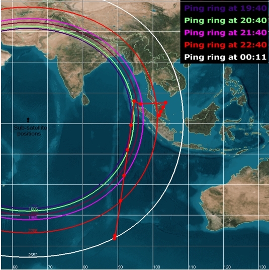
The diagram below shows the calculated path that MH370 may have flown based on Yap FF’s BTO/BFO calculator. It assumes a constant altitude of 10.7 KM (35,104 ft) and a constant track of 186° from the 18:39 UTC arc (Arc 1).
The variables entered to calculate the expected theoretical location of MH370’s end point are shown below.
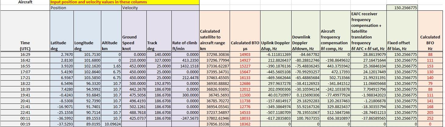
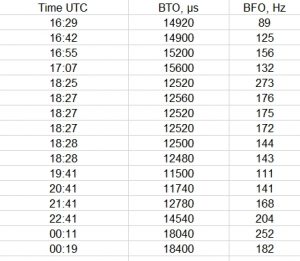
The calculated BTO and BFO values are shown in their respective columns in red and are the result of inputs from the position (Altitude) and velocity (Ground Speed, Track and Rate of Climb) variables. They can then be compared and verified with the actual BTO and BFO values logged by Inmarsat during the duration of MH370’s flight for the period between 16:29 UTC and 00:19 UTC shown in Figure 3 below.
In theory, if there is a match between the BTO/BFO from the actual Inmarsat data in Figure 3 with the BTO/BFO values calculated in Figure 2 with the calculator, then we can assume that the data in the altitude, ground speed, track and rate of climb/descent was the state that MH370 was in, for that instance in time. Furthermore, this calculator would suggest that the point of impact of MH370 was close to the latitude 37.53° S, longitude 89.02° E.
Since the BFO data indicates the relative motion of the aircraft with respect to the satellite, is it possible to come up with the same BFO values as the Inmarsat data, but for a relative motion that does not follow a flight path to the Southern Indian Ocean?
As a purely hypothetical exercise to answer this question, a number of random variables were entered in to the BTO/BFO calculator with the aim of maintaining the same BFO value at the key Inmarsat data time intervals, namely at arcs 1 through to 6 at 19:41, 20:41, 21:41, 22:41 and 00:11 UTC. The results of this exercise are shown below, where the altitudes, ground speed, tracks, and rate of climb/descent were adjusted with the aim of reproducing the same BFO, or as close as possible, to the BFO value from the Inmarsat data from MH370.
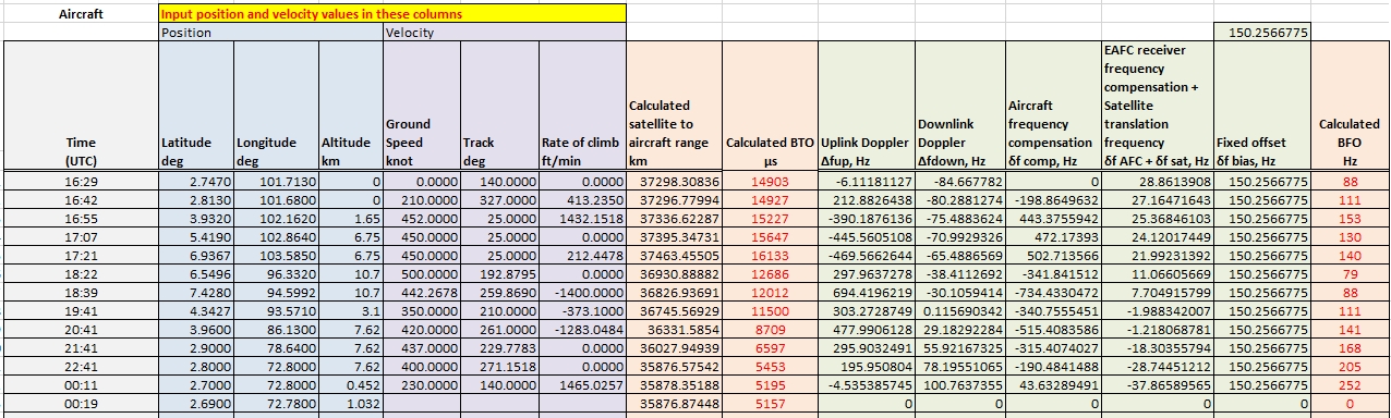
Comparing the Calculated BFO values between Figure 4 and Figure 2 above shows that they are identical. Comparing the Figure 4 BFO values with actual Inmarsat BFO values in Figure 3 shows a good correlation as well. As expected however, the BTO values will differ since the variables that were adjusted, such as the altitude, ground speed, track and rate of climbs will all result in a different relative motion to the satellite.
So where does the flight path for the Figure 4 values lead to? Figure 5 below shows the flight path for the Figure 4 values, where reiterating, the BFO values were all identical (except for 22:41 UTC where it differs by 1 Hz) to the Inmarsat BFO values.
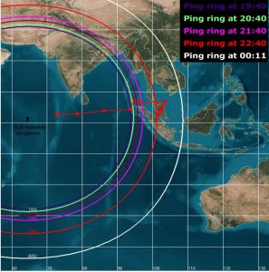
A point I’d like to make clear is that this is just a hypothetical exercise and does not suggest that MH370’s flight path resembles that shown in the diagram. But, we have a scenario here where the BFO values do match the Inmarsat BFO values but 5 BTO values differ from the Inmarsat data.
The BFO value at 19:41 UTC has been of interest in the past where some researchers suggest that the turn to the south towards the Southern Indian Ocean had occurred by this time. In Figure 4 above, the BTO and BFO values from the calculator are identical to those from the Inmarsat data, however, the BFO suggests the aircraft was tracking southwesterly on a track of 210° and descending at 310 feet per minute at approximately 10,000 feet altitude with a ground speed of 350 knots.